Overview
Tay Ninh is a province in the Southeast region of Vietnam. Tay Ninh is located at the bridge between Ho Chi Minh City and Phnom Penh, the Kingdom of Cambodia. Furthermore, the province is one of the provinces located in the Southern Key Economic Zone. The province of Tay Ninh city is located 99 km from Ho Chi Minh City along Highway 22, 40 km from the Cambodian border to the Northwest.
The land of Tay Ninh from ancient times was a land belonging to Thuy Chan Lap and was called Romdum Raym meaning "Elephant Stall" because it only had forests with wild animals such as tiger, elephant, leopard, snake and etc. The aboriginal people here live very deprivedly, extremely destitute until the Vietnamese people come to reclaim the land to become developed.
1/ Geographical location
Tay Ninh connects the South Central Highlands with the Mekong Delta which owns both characterized by a plateau, and appearance, and nuances of the plains, Its coordinates is from 10057'08 '' to 11046'36 from '' North latitude and from 105048'43 "to 106022'48 '' East longitude

Tay Ninh
The East borders Binh Duong and Binh Phuoc provinces, the Southeast borders Ho Chi Minh City, the South borders the provinces of Long An, the West and the North borders three provinces of the Kingdom of Cambodia: Svay Rieng, Prey Veng, and Tbong Khmum. It’s across the long border of 240 km with Moc Bai and Xa Mat international border gates and national border gates: Chang Riec, Ka Tum, Phuoc Tan and many small border gates.
2/ Natural condition
Like other southeast provinces, Tay Ninh Province is also a transitional terrain from the South Central Highlands to the Mekong Delta, the land is relatively flat.
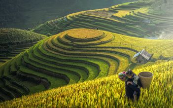
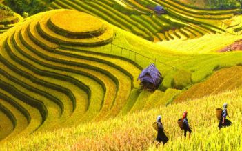
The terrain has the characteristics of a plateau, both in appearance and nuance of the plains. So, Tay Ninh has many different terrain areas such as mountainous terrain with Ba Den mountain 986 m high which is highest in South Vietnam, Phung Mountain with 435m high, and Heo mountain with 289m, mound and low hill with wide and weak wavy terrain varying from 15m in districts south to 115m in upstream of Dau Tieng Lake. However the average height of the whole province is only about 35m), the area has flat terrain, the flood plain is about 1m high. In general, the terrain of Tay Ninh is flatter than that of other Southeast provinces except for HCMC.
3/ Climate of Tay Ninh
Tay Ninh's climate is relatively mild in the form of a tropical monsoon climate which is divided into two distinct seasons, the rainy season and the dry season. The dry season usually lasts from December of last year to April of the following year, the rainy season starts from May to November.
Besides that, the temperature is relatively stable with an annual average temperature of 26-27 ° C, a record low of 12 ° C and a record high of 40 ° C and a low of 17 ° C in December to February of the following year. The highest is 36 ° C, lasting from April to May, with little change, and the average annual rainfall is 1800 - 2200 mm.
On the other hand, Tay Ninh is located deep in the continent, has a high terrain hidden behind the Truong Son Range, so it is less affected by storms in June to August will have strong winds in the southwest lead to the storm but strong winds and other favorable factors. With such advantages are favorable conditions to develop diverse agriculture, especially fruit trees, industrial plants, medicinal plants, and livestock breeding.

Tay Ninh
4/ Land
Tay Ninh has abundant land potential, over 96% of the land fund is favorable for developing crops of all kinds from water plants to short-term and long-term industrial plants and fruit trees of all kinds.
The land can be divided into 5 main soil groups with 15 different soil types. In particular, gray soil group accounts for over 84% and is the most important resource for agricultural development.
In addition, there is a group of alkaline soil accounting for 6.3%, yellow grass soil group accounts for 1.7%, alluvial soil group accounts for 0.44%, peat soil group accounts for 0.26% of the total area. Forest land accounts for more than 10% of the natural area.
Tay Ninh has Dau Tieng lake to help ecological balance which serves irrigation in agriculture, and provide water for aquaculture, as well as consumer activities and industrial production. The underground water source in Tay Ninh is widely distributed in the area, ensuring the quality of production and people's life.